Mapping Africa: Problems of Regional Definition and Colonial/National Boundaries
by Ralph A. Austen
 frica is perhaps the most "mapped" of the world's major regions. Back in my school days during the 1940s and 1950s, the continent was studied only in geography classes. If it appeared at all in studies of history or politics, the central issue was colonialism, which again involved maps of the boundaries which European powers had drawn between the territories they carved out for themselves. Once African Studies came into maturity as a study of developments within indigenous societies and cultures, there was an understandable hostility to maps as external impositions. Nonetheless, cartography is essential to grasping both the forces within Africa and the constraints--both natural and political--which continue to place this region at a disadvantage in the global order.
More specifically, maps can help us understand three major issues in the history of Africa: first, the physical and ecological factors which define this continent both internally and in relationship to the outside world; secondly, indigenous representations of space in the precolonial era, which provide a basis for putting more recent Western cartography into perspective; and, finally, colonial boundaries, which represent both European interventions in Africa and the continuing cartography of postcolonial development.
Continent/regions: Geometry and geography
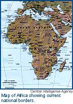 In its most basic cartographic representation, Africa is a well-defined geometric entity: a continent surrounded by natural bodies of water on all sides except for a small isthmus in the extreme northeast joining it to western Asia (and even this is now broken by the Suez Canal). There is, however, a geographic convention of dividing Africa into Mediterranean and sub-Saharan zones, with the former treated as an extension of the Middle East ("Maghreb" the Arabic term for North Africa means "West") while the latter is the "true" Africa. Another division distinguishes tropical and temperate zones, with the latter category including not only the Maghreb but also South Africa, whose relative hospitality to European settlement is thus explained. Such distinctions are not politically acceptable in present-day Africa (the Organization of African Unity includes states from all portions of the continent) but maps can help us decide whether they have any geographical and historical justification.
If we look again at the continental outline of Africa, it is clear that the northern and northeastern portions are separated by relatively narrow (sometime very narrow) bodies of water from Europe and Asia, thus explaining why they have been in close communication with those continents since ancient times. However, the Atlantic and Indian Ocean coasts--especially the former--are quite distant from other major land masses. Moreover, their coastlines have relatively few indentations, meaning that most of the inhabited areas are also far from any coast; compare this to profiles of Europe and the Middle East. Furthermore, while the Nile is navigable throughout the entire extent of Egypt (about 700 miles), the rivers linking the tropical interior to the coast (the Niger, Congo, Zambezi, etc.) are widely separated from one another and generally navigable less than 100 miles inland, where all of them encounter cataracts, due to abrupt rises in land elevation. Thus limits of water transportation--the most efficient means of long-distance carriage prior to the Industrial Revolution--left sub-Saharan Africa relatively isolated from the rest of the Old World and even internally divided for most of its history. The Sahara desert is also a barrier to land travel, although one that was breached (while far from eliminated) around 1 CE by the introduction of camels into the region.
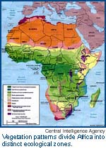 The vegetation map also indicates very different ecological patterns in the various parts of the continent. The savanna and tropical rain forest that dominate the tropical regions require different cropping patterns than the temperate zones and are generally less secure environments for the support of large populations. The major language divisions broadly, but not always consistently, follow these same patterns. The north and northeast are dominated by Afro-Asiatic languages, the tropical region by the Niger-Congo family and the south, until fairly recently, contained large areas in which the languages of aboriginal hunter-gatherers and pastoralists (Bushman/Khoi) were still spoken, indicating the late immigration of Niger-Congo (Bantu in this case) speakers (and very much later European arrivals). To divide Africa along these lines--Mediterranean, "Black African" and South African--may thus be perceived as "racist" but any more unified view of the continent must at least take into account the internal geography suggested by maps of physical endowments and the historical distribution of populations.
Precolonial mapsWhile cartography in sub-Saharan Africa is generally associated with outside perceptions and even economic and political impositions, there are indigenous traditions of representing space which pre-date colonial rule. Those most consistent with European practices are linked to Islam and Middle Eastern culture, which entered the sub-Saharan regions of the continent as early as the eighth century CE. Muhammad Bello, the highly literate ruler of the Sokoto Caliphate in the north of present-day Nigeria could thus provide early nineteenth-century European explorers with a reasonably accurate map of his domains and the major trade routes within them. However, it is not clear whether such visual representations were used for internal purposes within this state and political boundaries are not indicated with any degree of precision. In this case of formal visualization, just as in the oral statements about the spatial dimensions of African states recorded in many other instances (Wilks), power is seen as radiating out from a clearly defined center to more vague frontiers, sometimes marked by (but not necessarily identified with) natural features such as the Niger river (in the Sokoto case). This political cartography stands in strong contrast, as will be seen, to modern conceptions of statehood expressed in colonial (and postcolonial) African boundaries.
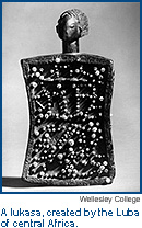 Precolonial African representations of space were not limited, however, to political and economic issues. The most developed and striking forms of cartography used landscape references to express ideas about identity, migration histories, mythology, and relationships with spiritual forces. They were definitely created for internal use rather than communication with outsiders and might take the form of elaborate artifacts such as the Luba lukasa or wall decorations, temporary drawings on the ground, body tattoos and even compass orientations inscribed on to objects which do not themselves represent space (Bassett).
These complex forms of indigenous cartography provide evidence of African ability to think systematically and graphically about space and force us to extend our own conceptions of maps (which were not always such "practical" devices in earlier European history). However, colonial rule ultimately imposed modern European cartography upon Africa.
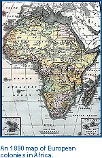
Colonial maps and national boundariesEuropean cartography is a complement of other technologies of political power: literate bureaucratic agencies (these existed in the Sokoto Caliphate and other African Islamic states, but in limited form), the need for regular tax collection and even, at times, conscription of populations for military or public works service. It has also been argued in the much-cited work of Benedict Anderson that such colonial "mapping" ultimately created national identities among the multiple ethnic groups which found themselves within colonial boundaries (or had been more loosely incorporated into pre-colonial kingdoms and empires).
Tropical Africa is a good test for this proposition, since colonial rule lasted here for less than a century, national states have been somewhat insecure entities since independence, yet the colonial maps have survived as the delineators of boundaries between these states. All this happened despite the arbitrary nature of much colonial map-making, which has been noted by many African critics. Conferences and diplomatic maneuverings in distant European capitals often drew lines to deal with tensions among the colonizing powers rather than addressing internal African issues. What has been less noticed are the frequent boundary changes made after the original partition to suit further intra-European concerns--most notable, but by no means the only one, being the outcome of World War I (Austen).
Whatever the grounds upon which colonial maps were drawn, it has not been easy to propose an alternative cartography which would better suit the natural or historical features of Africa, whether the landscape and indigenous states or ethnicity, now recognized as a fluid and often arbitrary set of markers, as much (pace Anderson) the product of internal colonial "mapping" as of more autonomous developments (Ranger).
 Colonial maps did impose some serious disadvantages upon Africa, although perhaps less due to the specific boundaries they established than to the way they imposed outwardly oriented development patterns upon the continent. "Balkanization" into numerous territories of varying sizes rather than a few big units is only a problem if one assumes that "bigger is better," which is not demonstrated by the relative success of various postcolonial states e.g. some of the very large ones such as the Republic of Congo and Sudan have experienced the most severe problems (Herbst 139-72). More significant, perhaps, was the competitive outward orientation of transport networks that did not link African territories to one another but rather tied each to a port within its own colonial domain and ultimately to trade with its European metropole. But this outward orientation and dependence upon modern infrastructures is also due in significant part to the internal geography of the continent, as already indicated.
It is also important to note that once African states gained freedom from European rule, they all became staunch defenders of the existing boundaries. The charter of the Organization of African Unity government thus contains an agreement by the signatory governments to "respect the frontiers [of all member states] existing on their achievement of national independence." In the extensive turbulence of postcolonial African politics, there have been very few attempts by states to take over significant portions of their neighbors' territories. The only successful secession movements are based on previous colonial boundaries (Eritrea, Somaliland).
Some scholars have argued that the existing boundaries are, nevertheless, arbitrary and that the states operating within them have attained only "juridical" as opposed to "empirical" sovereignty (Jackson and Rosberg). Juridical sovereignty refers to territorial entities maintained by agreements among outside powers (in this case both the international community and the rulers of other African states) rather than by real integration of the resident populations into a common political community. The ongoing crises in such states as Angola, the Congo, Liberia, Sierra Leone and Somalia suggest that colonial maps have not laid out a stable basis for nationhood in Africa. However, no alternative cartography suggests itself. The colonial regimes established boundaries that at least allowed the beginnings of complete territorial control although in practice, European rulers never attempted to exercise such control to the full degree that was demanded by subsequent African national regimes. (Herbst: 94-96). Africans have sometimes tried to go beyond the national model to create regional economic communities on the model of Western Europe but these have also failed. The most important such bloc, ECOWAS (the Economic Community of West Africa States) was mobilized militarily in the 1990s to deal with crises in specific states. But here too, the seeming emergence of the largest West African state, Nigeria, as a kind of dominant regional power could not be sustained due to the internal costs of such an effort.
The best clue that maps give us to the current situation is that areas with readily accessible mineral resources are more susceptible to the kind of "warlord politics" that actively challenge the sovereignty of colonial successor regimes. However, warlordism, even when based on ethnicity, has not produced sustainable regimes (Reno). Instead, it is another example of how external interests--in these cases buyers of easily exportable resources such as diamonds--may determine the geography of African power. For the present therefore, and perhaps for the immediately foreseeable "global" future, African cartography may be telling the same story as it did a half-century ago: that the modern "mapping" of this region is still linked to its asymmetrical relationships with outsiders.
Works cited in this article.
ABOUT THE AUTHOR |
Ralph A. Austen
Ralph A. Austen is Professor of African History and co-chair of the Committee on African and African American Studies at the University of Chicago. He received his Ph.D. from Harvard in 1966. His current research focuses on the political economy and cultural dimensions of European overseas expansion, the Atlantic Slave Trade in African and African-American memory, and the historical development of African oral and written literature (focusing on the Mande region of West Africa).
COPYRIGHT | This article is adapted from a workshop organized by the Centers for Latin American, Middle Eastern, East Asian, South Asian, and Eastern Europe/Russia/Eurasian Studies and the Committee on African Studies at the University of Chicago, June 18-29, 2001.