
Lower
West Side (continued)
Little Village
Because of its stability as a residential area, Little Village
has attracted black as well as Mexican families. Beginning
in
the early 1960s, blacks moved into the neighborhood from North
Lawndale. In the 1950s the area around Douglas Park experienced
rapid racial change from a Jewish community to a black neighborhood
(See
Fig. 1).
Primarily a district of apartment buildings.
North Lawndale soon became one of the most densely populated
black districts in the city. As a result of the riots which
occurred
following the assassination of Dr. Martin Luther King, Jr., in
1968, North Lawndale lost a large portion of its local businesses.
According to the 1980 census, Mexicans accounted for two-thirds
of Little Village's 75,000 residents. On the whole, families of
Spanish origin were more dispersed in the community than the 6,500
blacks who lived in the area. By and large, the transition from
an Eastern European neighborhood to a predominantly Hispanic one
has been peaceful.
Historically, the Lower West Side was divided into ethnic communities
which supported their own churches, fraternal and social institutions,
and newspapers. While Bohemians, Poles, and Slovenes lived in
the same area, they shared few common institutions. Although Mexicans
form the largest group on the Lower West Side and predominate
in the area's sixteen Catholic parishes, the tradition of separate
ethnic institutions persists. The General Mihailovich Veterans
Group, for example, continues to meet in the old Masonic hall
at 2300 S. Millard, and the Serbian Orthodox Church of St. Nikola
is still located at 2754 S. Central Park. While many former Protestant
congregations are now Spanish-speaking Pentecostal churches, a
small number of them have become black institutions. The original
Fowler Methodist Episcopal Church at 2255 S. Millard, for example,
is now the Greater Zion Hill M.B. Church.
� previous 11 of 13 next �
|
|
|
|
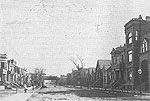
Figure 1:
Homan Avenue south from Ogden Avenue, c. 1909. �
|