Surviving
Navigation
Because Portugal is so close to the ocean, water transportation is
very important. The Portuguese turned to the skies to help guide them
when they were on the water and landmarks are not available.
It was not possible for the Portuguese to determine longitude (distances
east and west) at sea before the early 1500's. Determining longitude
required a timepiece that would keep track of time back home. At noon
they could compare the local time with the time back home and determine
how far east or west they were. The timepieces, however, were not good
enough to keep track of time for extended periods of time at sea. In
addition, the maps of
the
day often published inaccurate longitudes, making sailor's challenge to
reach the proper destination even greater.
It was quite easy, though, to measure the distance north or south of the
equator, which is called latitude.
Prior to 1500 the Portuguese used
the North Star (Polaris) to determine latitude. The North Star primarily
stayed in the same position in the night sky; around 1500 it moved
in a small circle with a 6 degree radius. Today the North Star does not
move in the night sky. Using the North Star to determine latitude only
worked as long as the mariners stayed well north of the equator because
the North Star is not visible below the equator.
Tools to help mariners determine latitude were developed around the 1500's.
In 1481 King John II ascended to the Portuguese throne, and consolidated
Portuguese control over the Gulf of Guinea (on the African coast near the
equator). In order to make navigation easier in the Gulf of Guinea and south
of the equator, King John had people in the royal court produce new instructions
and new tables that would make it easier to calculate latitude. These instructions
required two pieces of data: the height of the sun above the horizon at
mid-day, which the mariners could observe; and a number known as the solar
declination, which varied from day to day and which was tabulated in the
new tables.
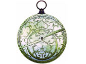
Astrolabe
and Quadrant:
To determine their latitude while at sea, they used tools called
the mariner's astrolabe and the quadrant. Both instruments are
used to determine the altitude of an object in the sky, or its
angle above the horizon. For both of these instruments, the earliest
records of their use at sea by people of any country come from
Portugal in the 1500's.
The mariner's astrolabe was a brass ring used to observe the
altitude of the North Star or the sun. This was a simple wooden
or brass disk with degrees marked around its edge. It had a rotating
arm with small holes
at either end. The disk would be hung vertically from a ring.
The user could move the arm until the sunlight shone through
the
hole at one end and fell on the hole on the other end. The arm
would indicate the altitude by the degrees marked around the edge of the disk.
Once they had the altitude, the seamen next consulted a special
almanac for a number known as the declination of the North Star
(or sun) on that day. By plugging both numbers into a special
equation, they were able to calculate their latitude.
Unfortunately, the mariner's astrolabe was not a very good instrument.
Errors of four or five degrees were common. When the mariners
miscalculated
latitude, they sailed so far in the wrong direction that it was
like driving your car to the wrong city today.
Navigators could also determine latitude by observing the North
Star or the midday sun through a quadrant. The quadrant was a
metal
plate
in the
shape of a
quarter-circle.
From the center
of the circle hung a weight on a string, which crossed the
opposite edge of the circle. The navigator would sight the North
Star
or the sun along
one edge, and the point where the string crossed the edge would
show the star's or sun's altitude, or angle above the horizon.
This gave
navigators a very close approximation of their latitude.
When the navigators neared the equator, the North Star fell
below the horizon. This forced navigators to rely on the sun,
mariner's
astrolabe and almanac to find their latitude.
Once they knew the latitude of their destination, they would first sail
to that latitude and then sail east or west along the latitude line until
they reached their destination.
«
previous 2
of 4 next
»

|