
With the same size telescope, a spectrograph capable of observing one object at a time and the information on images then known, it would have taken 5 years to obtain comparable SDSS quality spectra of 25,000 objects. This is about 2.5% of the number that was actually achieved in the 8-year project observing 640 objects at a time.
In a sense, the most pioneering aspect of the Sloan Digital Sky Survey, was the decision to make all of the digital data available to the public within two years of its being recorded. No telescope had previosuly achieved this level of productivity; it is now considered the standard for all large projects. Per dollar, it is the most productive telescope in the world. Two measures of productivity used by scientists are the number of papers per year and number of citations by other researchers. For SDSS these measures are 400 papers and 15,000 citations per year. It is in the top five by several other metrics. The projects with which it compares cost over twice as much to carry out, considering capital and operations cost. None of us expected anywhere near this level of impact on astronomy when the project started.
Compared with previous surveys, SDSS was set to obtain useful data on many more objects than anyone had ever tried to observe. The term "useful" is key here. The data had to be adequate to the scientific goals, carefully and uniformly calibrated, and the objects had to be chosen according to a strict set of rules to provide homogenous samples.
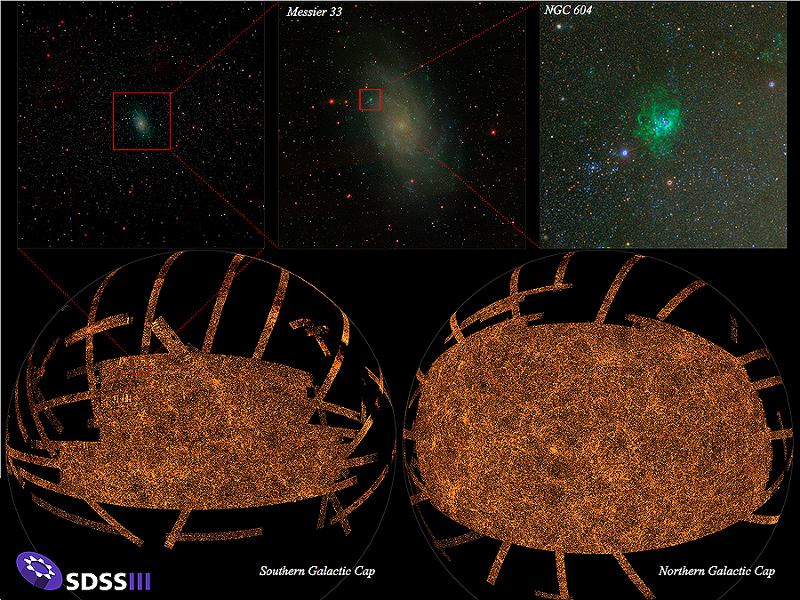
SDSS Sky Map: The bottom panel shows the sky coverage of the final SDSS imaging survey, including data from SDSS I, II, and III. SDSS imaging covered slightly more than 1/3 of the sky, concentrated in the northern and southern Galactic caps (above and below the plane of the galaxy). In this image, stripes are radiating out from these caps; these stripes are areas imaged by the SEGUE survey, extending toward the plane of the Milky Way. Each orange dot in this map is a galaxy. The sequence of zooms in the upper panels zeroes in on the star-forming nebula NGC 604 in the nearby (2.5 million light years) galaxy Messier 33. In all, the SDSS imaging map shown here contains more than a trillion pixels, each one imaged in five colors.
Credit: M. Blanton and the SDSS-III collaboration
The analysis could not be done by hand; it required powerful computers and completely new software for the analysis of the data. The computers and the software were there by the time the survey was completed, and the new high-speed internet allowed us to transfer data from APO to Fermi National Accelerator Lab near Chicago in a very short time. In other words, the project fell into a technology niche: it was the right time for astronomy; it was right time for getting dozens of CCDs; it was the right time for high-speed digital data transmission; and it was the right time for the necessary computer processing speeds.
